Look at a map of Santa Fe and you may wonder why rivers on nearby slopes head toward different seas. The geography of the Republic of Panama answers that question with a chain of high ground, a continental divide, and an isthmus more varied than its narrow outline suggests.
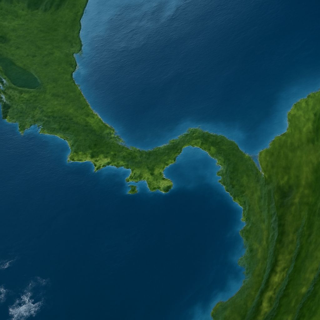
Panama sits in Central America, between Costa Rica and Colombia. Its land connects two continents while separating the Caribbean Sea from the Pacific Ocean. That compact setting makes it possible to follow a drop of rain from a mountain slope to the coast in a surprisingly short distance.
Panama, Central America, and the shape of the isthmus
An isthmus is a strip of land joining larger landmasses, with water on either side. Panama forms the southern end of the Central American land bridge, linking North and South America. The country bends roughly from west to east rather than running straight north to south. As a result, the Pacific lies south of much of the country, while the Caribbean lies to the north.
In Panama, Central America, the western border meets Costa Rica and the eastern border meets Colombia. Its shape includes peninsulas, islands, bays, and a mountainous interior. In the east, the Darién region meets Colombia; in the west, highlands continue toward Costa Rica. A map showing only the canal can make the country look like a thin passage, but the land around that passage has many distinct contours.
The geography of Panama is also a story of connection and separation. The isthmus provided a land connection between the continents and divided marine environments. A U.S. Geological Survey review describes the gradual emergence of the land bridge and closure of the seaway. The same strip of land is both a bridge and a barrier, depending on whether you have feet or fins.
The mountain backbone
Highlands run through much of the country, though they are a series of ranges and lower gaps rather than one unbroken wall. In the west, the Cordillera de Talamanca extends from Costa Rica into Panama. Volcán Barú, near the western border, is the country’s highest point at about 11,400 feet. Farther east, the Cordillera Central continues through the interior, including the mountains of Veraguas near Santa Fe.
Panama’s varied geography gains much of its vertical variety from these uplands. A valley floor, a forested slope, and a cloud-covered ridge may be close together on a map yet feel like different worlds. As moist air rises over elevated terrain, it cools, helping clouds form. Elevation, exposure to winds, and local topography all contribute to the patchwork of conditions found in the highlands.
Central Panama has lower terrain than the western highlands. Farther east, ranges and hills rise again, including the mountains of the Darién. The changing height of the interior matters: it shapes how air moves across the isthmus and where streams gather before flowing toward a coast. Panama’s physical geography is best understood as a sequence of ridges, valleys, and low passes, not a single straight mountain crest.
Lowlands, valleys, and the coast
Below the mountains, river valleys open into plains and coastal lowlands. Pacific lowlands include broad areas around the Gulf of Panama and extend into regions such as the Azuero Peninsula. The Caribbean side also has low-lying coastal areas, with lagoons and islands among its varied shorelines. In some places hills approach the sea; elsewhere rivers have room to spread sediment across flatter ground.
The two shores have different shapes. The Pacific coast has large gulfs, including the Gulf of Panama and Gulf of Chiriquí, as well as the prominent Azuero Peninsula. The Caribbean shore includes the Bocas del Toro and Guna Yala archipelagos. Bays, islands, estuaries, and mangroves add finer detail to both coasts, although their extent and conditions vary from place to place.
Tides provide another contrast. The Pacific generally experiences a much larger tidal range than the Caribbean, so a stretch of shoreline may look very different at high and low water. On the Pacific side, exposed mudflats and mangrove edges show how the meeting line between land and sea moves through the day.
A divide that directs the rivers
A watershed is an area of land that drains to a common outlet. A divide is the high ground separating neighboring drainage areas. Across the isthmus, the continental divide separates land draining toward the Caribbean from land draining toward the Pacific. It follows elevated terrain but is not a perfectly straight line or always the highest visible peak.
Rain falling on one side can join small streams that feed a Caribbean-bound river; rain falling on the other can enter a Pacific-bound system. Tributaries combine downstream, carrying water and sediment through valleys toward estuaries and the sea. Local ridges create smaller divides within those larger drainage patterns. The landscape is a nested collection of catchments, each with its own network of slopes and channels.
The Canal watershed offers a particularly clear example of how geography and human infrastructure meet. Its rivers and lakes collect rainwater in central Panama. According to the Panama Canal Authority, the watershed supplies water for canal transits and drinking water for nearby urban populations. Gatún Lake is part of the canal system, linking a drainage landscape to a route between the seas.
Rainfall and the two sides of the divide
Panama in Central America receives tropical rainfall, but the pattern varies with season and location. Moisture arriving from the Caribbean and the orientation of the highlands help produce differences between slopes. The Smithsonian Tropical Research Institute notes that the Caribbean side generally receives more rain than the Pacific side; the Pacific also has a more pronounced dry season in many areas. A national average would hide quite a bit of weather in that fold of the map.
The Panamanian republic’s landscapes respond to those differences. Wet uplands can support cloud forest, where persistent moisture gathers around vegetation. Drier Pacific areas include seasonal forests, while rivers and wetlands connect interior habitats to the shore. Local elevation and exposure matter alongside the broad coastal pattern, so neighboring valleys can have their own character.
For a final picture of the Panamanian republic, trace the connections: mountains and hills shape the divide; the divide directs runoff into river basins; rivers carry water and sediment to Caribbean and Pacific coasts. Each coast meets that flow under its own marine and seasonal conditions.